Reproduce actual refraction measurements
Ray tracing HOSIVR (using the integration along the
apparent altitude path: Hohenkerk&Sinclair, 1985 and ARCHAEOCOSMO (and Excel).)
will be compared with actual refraction measurements that have
detailed (meteorological) data, such as: date, time, locations,
temperature, temperature gradient, air pressure, RH, wind speed,
cloud cover, cloud height, mirages/green flashes.
The following types of refraction have been studied:
- Astronomical refraction
The refraction is determined for a light path from the eyes'
position to the end of the Earth's atmosphere (in direction of a
celestial object).
- Levelling
refraction
The refraction is determined for a light path that has a
large part level with the Earth's geoid, aka towards/from a vast
level surface below the eyes' position. Also known as dip.
- Terrestrial refraction
The refraction is determined for a light path that goes from
the eyes' position to a terrestrial object higher or lower than
the eyes' position.
In several cases a combination involving levelling refraction has
been observed.
Astronomical (involving
leveling/terrestrial) refraction
The measurements are from Schaefer&Liller (1990) and Sampson
(1994, 2003, 2008). Both these
astronomical refraction measurements involve levelling refraction,
as the Sun is seen setting or rising over a vast level surface (Sea
or Earth).
These measurements also provide information on:
- Schaefer&Liller (1990)
Date, time, locations, temperature, air pressure, RH, wind
speed, wind direction and green flashes. Some data has been
rectified/updated (Schaefer, pers. comm, 2006). The sea
temperatures (a proxy to determine the temperature gradient) are
derived through for instance this link. This will involve the sea as
vast level surface: so levelling refraction is involved.
- Sampson (1994)
Date, time, locations, temperature, temperature gradient, air
pressure, RH, wind force, wind direction, cloud cover, cloud
height and mirages/green flashes. This data is transcribed from
Sampson's observation log book (Sampson, pers. comm. 2007) and
MSc thesis (Sampson, 1994). This involves hills around Edmonton,
Canada: so terrestrial (with perhaps some levelling) refraction
is involved. The temperature gradient was taken from a balloon
soundings at 0:00UT or 11.00 UTC (aka 16:00 or 04:00 MST),
so not that close to Sunset/rise, considering the dynamics of
the day.
This is compared to HOSIVR with the following date:
Sampson's observer: date, time, location, temperature, pressure,
calculated astronomical refraction; at weather station:
temperature gradient; and using ARCHAEOCOSMO/Swiss Ephemeris: topocentric altitude of
Sun.
These measurements are compared with the results of ray tracing HOSIVR.
In these cases the astronomical refraction is determined by using
the topocentric altitude (as the time of first/last glimpse of the
Sun can be determined) instead of apparent altitude. The MUSA76
height temperature profile has been used for the simulation (vdWerf,
2003).
Some conclusions around Schaefer&Liller's astronomical
refraction
<to be worked on>
Some conclusions around Sampson's astronomical refraction
- Here is an overview of the astronomical refraction calculated
by Sampson and by HOSIVR:
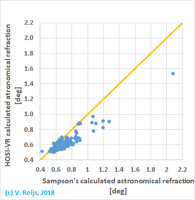
- It looks that HOSIVR calculates systematically a
lower astronomical refraction than Sampson.
- The Temperature gradient looks to be quite larger on average
+0.037K/m, this normally happens on clear nights but not that
many times at Sun rise (which
would be closer to D). So the question is: can the
provided balloon sounding data be used for this Sun rise
evaluation?
- If the temperature gradient was higher
than around +0.12K/m, HOSIVR is not able to calculate
the refraction (brown crosses, in 3% of the events):
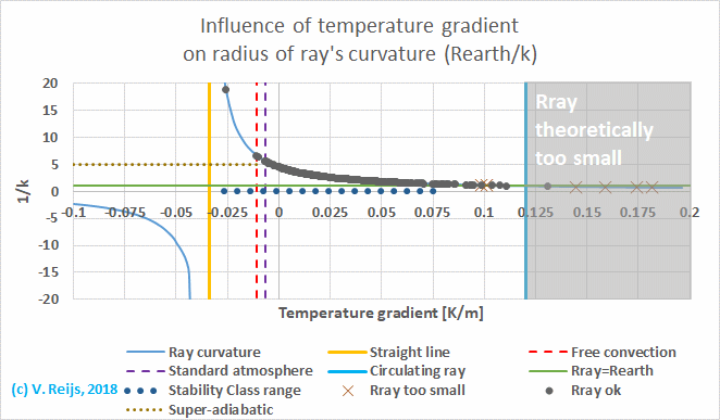
The main reason is because the light ray radius is smaller than
the Earth's and thus no visibility of the sky (but a Fata
Morgana).
General observations on astronomical refraction
<to be worked on>
Levelling refraction
No actual only levelling refraction measurements have been
evaluated yet (see above).
Terrestrial refraction
Sampson
As part of Sampson
astronomical refraction measurements, he also performed
theodolite survey of the horizon (Sampson, 1994, 2003).
The following issues can be found around his measurements:
- These measurements are at the middle of the afternoon on clear
summer or autumn days and noted at observer: location,
temperature, pressure, measured apparent altitude; and at
weather station: temperature gradient.
According to Sampson (2003, 1258): "The horizon altitude
measurements were made during the middle of the day when
terrestrial refraction was assumed to be minimized as a result
of boundary layer mixing (Bomford,1980)". Indeed these moments
are expected to have the lowest temperature gradient (due to solar insolation), but
this is a quiet different situation then at Sunset/rise. For the
terrestrial refraction evaluation of the survey data only this
fact is though not important.
- The temperature gradient was taken from a balloon soundings at
0:00UT (aka 16:00 MST), so that is close enough to middle of
afternoon, considering the dynamics of the day.
- The survey data compared to calculated HOSIVR with
the following date: Sampson's observer: location, temperature,
pressure, measured apparent altitude; at weather station:
temperature gradient; and using HeyWhatsThat
(which uses a constant temperature constant): distant height and
distance.
- For many cases in the direction of Sunset (~85%) and several
of Sunrise (~30%), the terrestrial path between the targets that
have almost a zero apparent altitude that can't be determined.
My present iterative terrestrial refraction function is not yet
able to determine if levelling is also involved. As levelling is
happening here, the terrestrial refraction function is being
reworked (aka incorporating levelling refraction).
In the meantime all Sun set observations were not included in
the evaluation.
Some conclusions around Sampson's terrestrial refraction
The comparison between surveyed
apparent altitude and calculated apparent altitude (using HOSIVR)
can be seen in below picture (to eastern horizon):
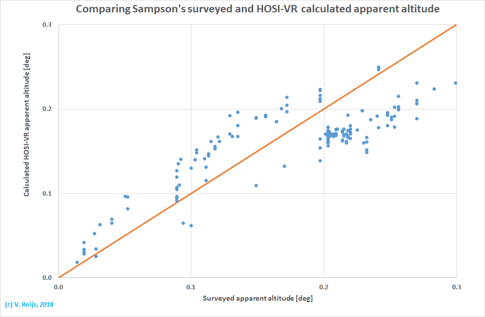
The standard deviation between the two is around 140", which looks
large. There seems to be a systematic difference for points above
and below the orange (unity) line. This looks to be related to the
time of the year: March-Sept (above orange line) and Oct-Feb (below
orange line. This is a little strange as the theodolite survey was
not done on the dates that determined the azimuth (of Sun rises).
Thom
Thom's terrestrial refraction
measurements (Thom, 1958) have been evaluated, which include:
date, time, locations, temperature, temperature gradient, air
pressure, wind speed, wind direction and cloud cover.
No final analysis is yet made, but a few issues have been
experienced when evaluating around hundred of Thom's observation.
Would interesting to get your feedback:
- In some cases (~13%), Thom observed
terrestrial targets (HI and Pl which are very close to the sea)
which are below the Eye height. In that case the temperature
gradient measured (an LABL environment) by Thom if of no use, as
the light rays don't pass the atmosphere where the temperature
gradient sensors are (which are at 0.75 and 7.5m near the Eye
location). For example: an average December sea temperature around Arran
Island of around 10C is used to determine the temperature
gradient (aka MABL
and not a LABL environment). Thom did not include these
two targets in his evaluation, most likely because if this ABL
difference.
If this MABL is used, no solution is found using the ray
tracing (reason yet unknown. If you have ideas,
let me know), so for the
present evaluation the LABL has been used.
As mentioned on this archaeocosmology web site: people need to
determine the temperature gradient not only at eye height, but
they need to try to record the
temperature profile along the ray path (RPTP).
- For some instances (~9%), Thom measured
temperature gradients higher than +0.11K/m. In these cases one
is not able to calculate the ray tracing integral (because the ray
radius is
smaller than the Earth's radius). It would be interesting
to understand what Thom would have seen through his theodolite.
If a Fata Morgana (aka superior mirage), then it would have been
expected that Thom would have observed and noted such
distortions!
To include in the evaluation: the temperature gradient has
been capped to +0.11K/m if it was higher.
Mitigating circumstances could have been present, to make
explain why Thom could observe the targets without
distinguishable/note-worthy distortions:
- his temperature gradient measurements and/or my evaluation of them,
are wrong.
In some cases the first could be true as the distant object
was below eye height, see earlier bullet.
- the atmosphere is not spherical symmetrical
This sounds logical in a hilly environment which changes the
meteorological circumstances (such a down winds)
and thus tampering with spherical symmetry,
- Any other ideas (let me know)?
- For some cases (~4%), the terrestrial path between the targets
that have almost a zero apparent altitude that can't be
determined (-0.06deg; The Hill at 149m and AC at 340m, distance
62km). My present iterative terrestrial refraction function is
not yet able to determine if levelling is also involved. As
levelling is happening here, the terrestrial refraction function
is being reworked (aka incorporating levelling refraction).
In the meantime these observations were not included in the
evaluation.
- There is one case (~1%, Pl) where Thom's temperature gradient
is too low (+0.019K/m at Eye height) to determine a valid ray
trace integral. If it is increased to +0.05K/m a result is
gotten.
This could be because the target is near the sea and below eye
height, so using the measured temperature gradient at Eye height
is no use. But this does not explain the result of ray tracing.
To include in the evaluation: the temperature gradient has
been set at +0.05K/m.
Still strange that a +0.019K/m in principle does not work for
this case. Any ideas, let me know?
Some conclusions and Thom's terrestrial refraction
When comparing to Thom theodolite measurements: the HOSIVR
implementation provides better results (standard deviation around a
factor two smaller) than TerrestRefractVR
when using the wind speed as the proxy for the temperature gradient
(see also this link for this
wind speed dependency). If the measured temperature
gradient (capped at +0.11K/m) of Thom is used in TerrestRefractVR,
then the TerrestRefractVR results are five to ten times
less accurate as when using the wind speed as proxy.
We though have to remember that the standard deviation in Thom's
measured apparent altitude is in the order of 15", which is
larger than the error seen in the refraction difference with the
calculated HOSIVR and TerrestRefractVR, which
can be around 5".
Looking at this error analysis of terrestrial refraction, it would
be difficult to state that ray tracing is much better than the
approximation formula.
General observations on terrestrial refraction
<To
be filled in>
References
Hohenkerk, Catherine Y., and A.T. Sinclair. 1985. "The computation
of angular atmospheric refraction at large zenith angles." ed. by HM
nautical almanac office. Cambridge.
Sampson, Russell D. 1994. 'Astronomical refraction at Sunrise and
Sunsets', MSc thesis, University of Alberta.
Sampson, Russell D., Edward P. Lozowski, Arthur E. Peterson, and
Douglas P. Hube. 2003. 'Variability in the astronomical refraction
of the rising and setting Sun', Publications of the Astronomical
Society of the Pacific, Vol 115: pp. 1256-61.
Sampson, Russell D., Edward P. Lozowski, and Arsha Fathi-Nejad.
2008. 'Variability in low altitude astronomical refraction as a
function of altitude', Applied optics, Vol 47: pp. H1-H4.
Schaefer, Brad E., and William Liller. 1990. 'Refraction near the
horizon', Publications of the Astronomical Society of the Pacific,
Vol 102: pp. 796-805.
Thom, Alexander. 1958. 'An empirical investigation of atmospheric
refraction', Empire Survey Review, Vol 14: pp. 248-62.
Werf, S. Y. v. d. (2003) Ray tracing and refraction in the modified
US1976 atmosphere. Applied optics, Vol. 42, pp. 354-366.
Acknowledgements
I would like to thank people, such as xxxx
and others for their help and constructive feedback. Any remaining
errors in methodology or results are my responsibility of
course!!! If you want to provide constructive feedback, let me know.
Disclaimer and Copyright
 Home
Home Up
Up Search
 Mail
Mail
Major content related changes: January 5, 2018