NEW
Beside the above skyline profiles programmes, Mike Wilson manages
the Mega-What
website which has skyline profiles from several Irish Axial
Stone Circles (ASC) based on real panorama photos and theodolite
measurements. A great database! The height of the recording
equipment is around 1.25m.
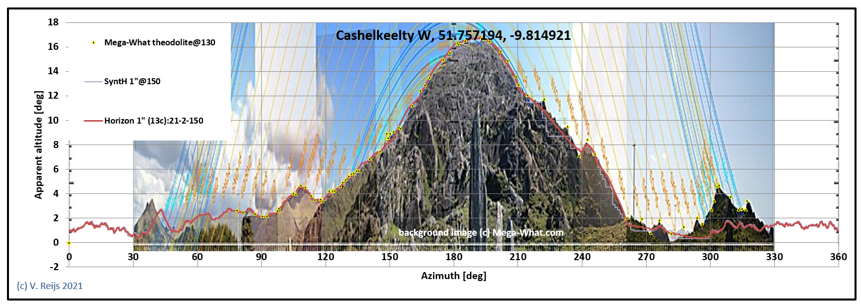
So the results of the above four computer programmes have been compared with Mega-What theodolite measurements and panorama photos.
The comparing results of the four programmes and theodolite measurements of the panorama photo can be seen in the below Fig. 1.
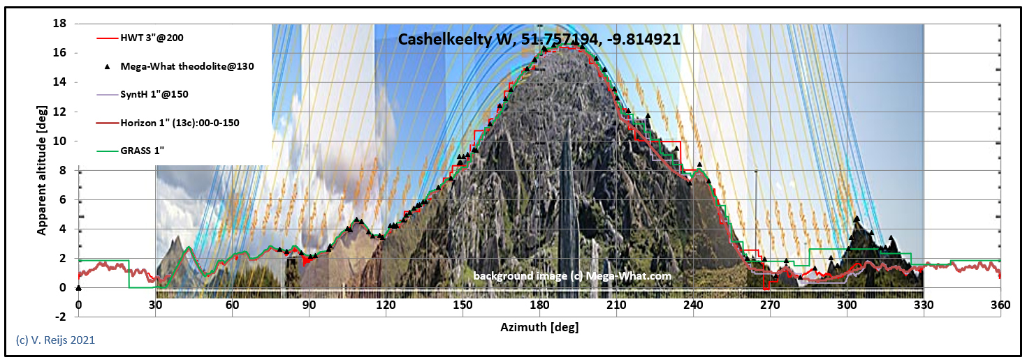
Fig. 1 Comparing skyline profiles from
computer programmes: HeyWhatsThat (red [SRTM
3"]), SyntH (purple [SRTM 1"]),
Horizon (orange [SRTM 1"]) and r.horizon (green
[STRM 1"])
with theodolite/photmetric measurements from Mega-What (black
triangles/background)
In Fig 2 there is a comparison between SyntH,
Horizon and StandingStones-linear.
SyntH (SRTM 1") and r-horizon (STRM
1") is quite close to the theodolite measurements, while HeyWhatsThat
(based SRTM 3") a little less.
The computer skyline profiles don't map the Mega-What
theodolite measurements sometimes, like: the small evaluation
around 310 azimuth (this is a small nearby hill); and the peaks on
the right side of the hill. If a lower eye height (say 0.5m) would
be chosen, this small hill will emerge in the skyline (like in r.horizon).
The skyline profile of Horizon programme and StandingStones-lineair
webpage have the same outline (as tested for STRM 1"), but both
have somewhat different apparent altitudes around azimuth between
120 and 270 deg compared to the others. The difference is due to
parallax: the nearby horizon (200m to 600m) and the low resolution
of STRM 1" (see next section).
In an earlier panorama of Mega-What there was
a shift of the small hill (at azimuth of ~40 degrees), this was
due to misalignment when stitching the panorama photos. This was
improved with the help of the above computer programmes.
| Site |
Latitude [o] |
Longitude [o] |
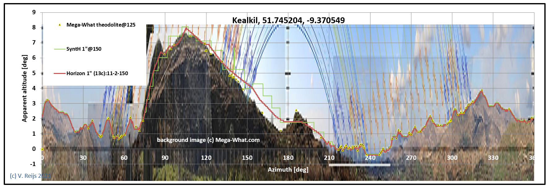
| Kealkil |
51.745204 | -9.370549 |
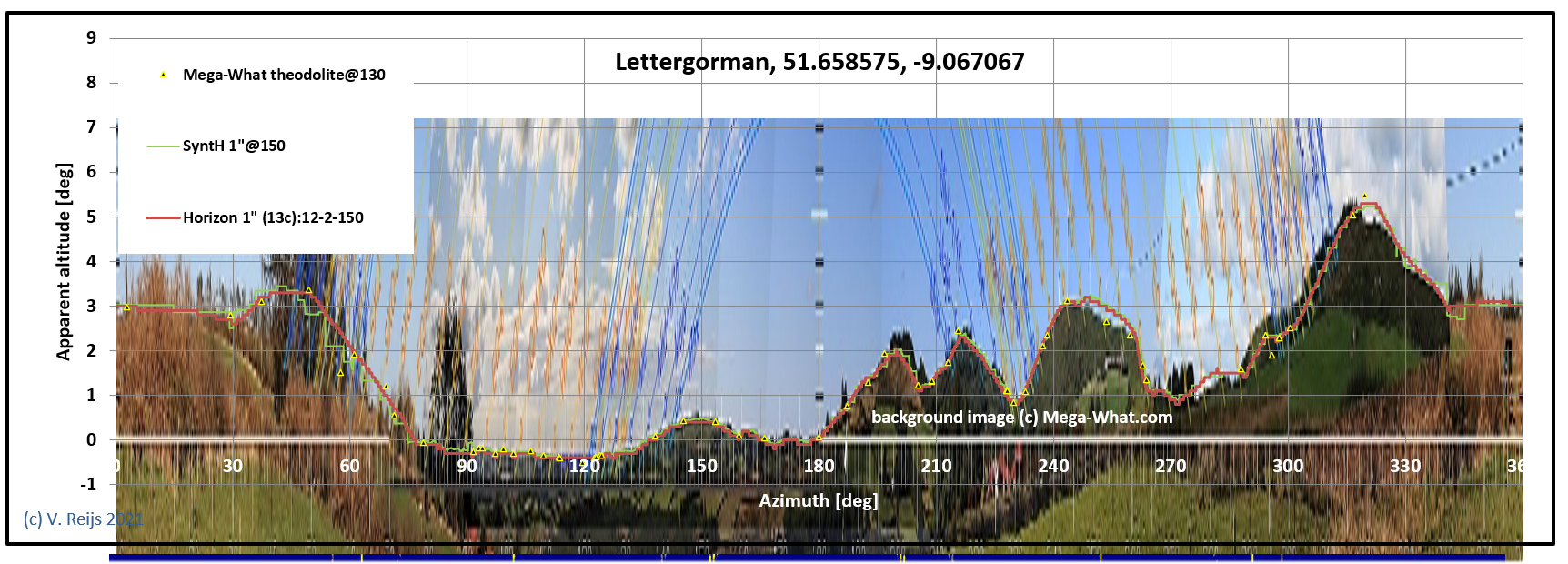
| Lettergorman |
51.658575 | -9.067067 |
| Cashelkeelty West |
51.757194 | -9.814921 |
| Site |
Square q*q [m] |
Most matching corner |
Most matching eye height [m] |
Figure |
| Kealkil |
20*20 |
SW |
1.5 |
3 |
| Lettergorman |
20*20 |
NW |
1.5 |
4 |
| Cashelkeelty West |
20*20 |
SE |
1.5 |
5 |
Careful stitching of panorama photos (like in Mega-What) is essential to overcome photo distortions and rotation errors. That is why theodolite (reference) measurements or computer programmes comparisons are important.
Of course a photo (or theodolite measurements) can be most of the time better than a computer programme. But for photos one needs to have the opportunity to visit the site at clear weather conditions, which is not always possible. So computer programmes can help solve issues with far away skylines, due to atmospheric conditions they are sometimes not visible on photos/theodolite.
For skylines further than 5km, all programmes, datasets and the
photo give similar results.
The above comparison shows that the SRTM 1" dataset (30m resolution) is better (due to a higher resolution) than the SRTM 3" dataset. And one can assume that LIDAR would even be better (as it has a resolution of around 0.5m or better). The artifacts seen in STRM1" though would be very similar with LIDAR; except the nearby horizon would need to be 60 times nearer by. So it is important, regradless of dataset, to have the correct rendering methodology.
Both HeyWhatsThat, SyntH and r.horizon
follow more or less the skyline shown in the Mega-What panorama
photo. The SRTM 1" resolution (min. 30m) is too low to depict
nearby features (say closer than 1.6 km) accurate enough (say
better than a forth of the Sun/Moon's diameter) in the skyline.
One has to remember that low level vegetation will have influence on STRM (not so much on LIDAR
and perhaps theodolite). And for nearby hoirzons this can also
bring up differences
The height plateaus in HeyWhatsThat, SyntH and r.horizon
could perhaps be made more natural(?) by using a proper
smoothing/interpolation method, such as linear interpolation.
Horizon and StandingStones-linear are very similar
and have a slightly different skyline seen for a Mega-What
location, and this can be expected due to parallax of nearby
horizon and the low resolution of STRM 1".
A combination of all methods (visits, photos, theodolite and
computer programmes) is really important to appreciate reality.